About Pont de la Caille
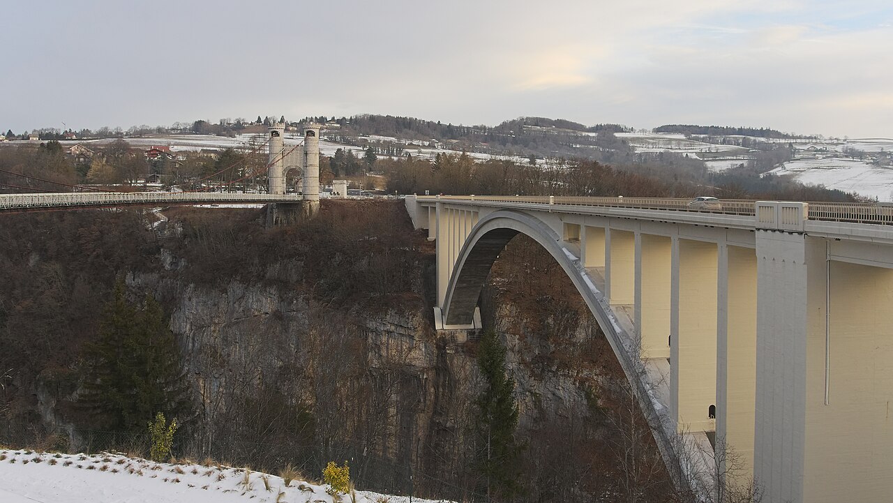
The Pont de la Caille — officially the Pont Charles-Albert — is a steel-cable suspension bridge inaugurated on 11 July 1839, straddling the communes of Cruseilles and Allonzier-la-Caille. It is 180 m long and crosses the Usses gorges at a height of 147 m. Listed as a Historic Monument since 6 May 1966, it belongs to the Haute-Savoie Departmental Council and is one of the 25 emblematic tourist sites of the Auvergne-Rhône-Alpes Region.
Next to it stands the Pont Caquot, or Pont Neuf, built between 1924 and 1928 under the direction of engineer Albert Caquot. Its unreinforced concrete arch was one of the largest vaults in the world at the time. It is this bridge that carries today's traffic on the RD1201. The Pont Charles-Albert, relieved of vehicle traffic since 1929, is reserved for pedestrians and cyclists. One site, two bridges, one history.
What you can do there
Cross the Pont Charles-Albert on foot
Fully pedestrian deck since 1929. Wooden planks, plunging view of the Usses 147 m below.
Interpretation trail
Four bilingual French-English panels trace the history of the site, the three bridges and the old thermal baths.
Panoramic walkways
Metal walkways extending over the void on either side of the bridge, for observing the gorges.
Picnic area
Tables, benches and loungers on the Cruseilles side, in a landscaped wooded area.
View of the Aravis range
From the bridge, view on one side of the Usses gorges, on the other of the Aravis mountain range.
Hike to the Crêt de la Dame
Loop from the site or from Allonzier-la-Caille, yellow-on-green markings. View of Lake Annecy from the summit.
Descend to the old Bains de la Caille
Path down to the remains of the former thermal baths at the bottom of the gorges. Sulphurous spring. Disused site, degraded condition.
Guided heritage tour
Tours organised by the Patrimoine Savoie Mont Blanc guides, on request via the OT Fier et Usses.
Practical info
How to get there
By car
On the RD1201 between Annecy and Cruseilles, ~20 min north of Annecy and ~20 min south of Saint-Julien-en-Genevois. From the A41 motorway, exit Allonzier-la-Caille, then RD1201 towards Cruseilles. Free parking on both sides of the bridge.
By bike
Accessible via the RD1201. The Pont Charles-Albert itself is open to cyclists since its pedestrianisation.
When to visit
The site is accessible year-round. A few markers:
- Spring – autumn: favourable light on the gorges, vegetation of the Usses below.
- Summer: higher attendance, the Cruseilles car park fills up. Arrive early or late in the day.
- Winter: site accessible, bridge sometimes windy. Warm clothing advised.
Night-time events and guided tours by the Patrimoine Savoie Mont Blanc guides are organised occasionally. Information from the OT Fier et Usses.
Where to eat, drink, stay nearby
Photos of Pont de la Caille


Share your photos: tag #loisirs74 on Instagram or email them to photos@loisirs74.fr. We pick the best and credit them to you.
Frequently asked questions
Is access to the Pont de la Caille paid?
Can you cross the Pont de la Caille by car?
How high is the Pont de la Caille?
Can I bring my dog to the Pont de la Caille?
Is there parking at the Pont de la Caille?
Is the Pont de la Caille a listed Historic Monument?
Can you descend to the old Bains de la Caille from the Pont de la Caille?
Is the Pont de la Caille suitable for people with vertigo?
- Office de Tourisme Fier et Usses — Pont de la Caille Charles-Albert
- Communauté de Communes du Pays de Cruseilles — Site des Ponts de la Caille
- Haute-Savoie Tourisme — Pont de la Caille Charles-Albert
- Wikipedia — Pont de la Caille
- Monumentum — Pont suspendu de la Caille (Cruseilles, PA00118386)
Cross-checked across multiple sources at publication date. Information may change — confirm with the official operator before a specific visit.